
Stansted Road has more reported flooding incidents than any other road in East Herts, a new council study says. The streets, river banks and sewers it flags.
Stansted Road in Bishop’s Stortford has more reported flooding incidents than any other road in East Herts. That is one finding of a new district-wide flood study, which went to the council’s Executive on Tuesday 6 October.
The study is a Level 1 Strategic Flood Risk Assessment, written for the council by the consultants JBA. It is the first full update since 2016. Once agreed, it becomes evidence for the new Local Plan and a material consideration when the council decides planning applications.
The council was asked to agree it at the meeting. When we checked on Wednesday morning, the decision notice had not yet been published on the council’s decisions page. The covering report and the 127-page study are both public on the meeting page.
The roads that flood most often
Hertfordshire’s highways team gave the consultants its records of flooding and drainage incidents from April 2020 to January 2026. The study charts the road names with the most reports; twelve appear, because of a tie for tenth place. Stansted Road comes first, with about 78 incidents. Five of those involved a flooded footway; the rest were the road itself.
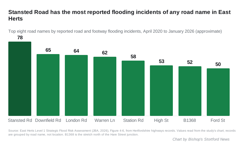
The approximate counts, read from the study’s chart, are:
| Road name | Reported incidents, Apr 2020 to Jan 2026 |
|---|---|
| Stansted Road | about 78 |
| Downfield Road | about 65 |
| London Road | about 64 |
| Warren Lane | about 62 |
| Station Road | about 58 |
| High Street | about 53 |
| B1368 north of the Hare Street junction | about 52 |
| Ford Street | about 50 |
| Stanstead Road | about 43 |
| Ware Road, Cromwell Road, Brickendon Lane | about 42 each |
Two cautions. The study groups the records by road name and gives no locations, so London Road, Station Road and High Street will each combine several towns. Stansted Road is a clearer case: in East Herts the name belongs to the road running north out of Bishop’s Stortford towards the airport. Stansted Road (with a “d”) and Stanstead Road (with “stead”) are different roads, and the study lists them separately.
Five recorded floods in the town
Hertfordshire County Council, as the lead local flood authority, investigates floods that meet set criteria and publishes a “Section 19” report. The study summarises three Bishop’s Stortford investigations:
- Stort Road and Wharf Road, June and September 2016. Moderate rain on 23 June 2016 flooded four properties externally. Intense rain on 16 September 2016 overwhelmed the surface water drains and affected five properties, two of them inside.
- Stort Road again, 13 August 2020. Three properties flooded internally after intense rain.
- Stortford Hall Park, 13 August 2020. Rain fell for 17 hours. A blocked trash screen made the Stortford Hall Park River overtop its banks and three properties flooded internally. The Thames Water foul sewer was also overwhelmed.
- Rye Street and Stane Close, 13 August 2020. Six properties on Rye Street and three on Stane Close flooded externally. Gullies were blocked or surcharging, and residents reported foul manholes surcharging on Rye Street. The study says that “despite a detailed investigation, the exact cause of the flooding remains unclear”.
Two newer problems are noted too. The county council reported significant flooding of the road in two places in the Hockerill area during winter 2025/26. In both, water in culverted sections of the main river is thought to have backed up onto the road. And a watercourse near Brooke Gardens, on the east side of town, has been investigated after flooding under the Dunmow Road overpass reached the industrial area beside it. The study says the cause “is not clear”.
Across the district, the county’s records since 1996 show the most flood incidents in Ware, Hertford and Bishop’s Stortford, in that order.
The Stort’s banks: 16 embankments, condition unknown
The study reproduces the Environment Agency’s register of raised flood defences. For the River Stort in Bishop’s Stortford it lists 16 embankment sections and three walls.
- All 16 embankments are maintained by a “private individual, company or charity”, not by the Environment Agency or the council.
- Their actual standard of protection is recorded as unknown, and so is their condition.
- Of the three walls, one is maintained by the Environment Agency. Two carry a condition grade of 2, which the Agency defines as “good”: minor defects that will not reduce performance.
The study warns developers not to “assume that any defence, asset, or watercourse is being or will continue to be maintained” for the life of a development.
Sawbridgeworth had the most sewer floods in 2025
Thames Water gave the consultants its 2025 records of sewer flooding. The study maps them by ward. Sawbridgeworth ward, about four miles south of Bishop’s Stortford, had the most of any ward in the district, at 10. Hertford Castle ward came next. Twenty of the district’s 32 wards recorded none.
The Canal and River Trust also holds 12 records of the Stort Navigation overtopping its banks inside the district. Six of them are at Sawbridgeworth, including the path under Kecksys Bridge, and three at High Wych.
Where climate change adds most
Using the Environment Agency’s flood map with a climate change allowance, the study lists the places where flood extents grow most. Two are on the Stort:
- the River Stort south of High Wych
- an unnamed tributary of the Stort through southern Sawbridgeworth
On surface water, the study says the risk is highest in the built-up areas of Bishop’s Stortford, Hertford, Ware and Buntingford. It says Sawbridgeworth “is not modelled to be as severe”.
What it means for you
- If you are buying or renting near the Stort, check the address on the government’s long-term flood risk service. The study itself says its surface water maps are not for judging individual properties.
- If a road or drain floods, report it to Hertfordshire County Council. Those reports are the records this study counted.
- If you live near a planning site, this study will now shape which land is allocated for homes and what drainage developers must show. Our planning applications page explains how to comment on a scheme.
- For live flood warnings on the Stort, the Environment Agency issues them for “The River Stort at Bishops Stortford including Spellbrook”. You can sign up for free alerts.
We will update this page when the council publishes the Executive’s decision.
Have your say